Longtime NBC correspondent Martin Fletcher issued an unusual apology on Saturday for misleading his audience when discussing the history of the Israeli-Palestinian conflict the day before on MSNBC.
Fletcher’s segment, embedded below, displayed a series of maps produced by anti-Israel activists that purport to show how much land the Palestinians have lost since the 1940’s.
Believe it or not, the @MSNBC Kate Snow / Martin Fletcher voiceover was even worse than the map. pic.twitter.com/yJzGifrz8b
— Omri Ceren (@cerenomri) October 16, 2015
Fletcher’s apology came after being criticized on Facebook by a man named Daniel Laufer. “Kate Snow & Martin Fletcher air blatantly false map series produced by Palestinian propagandists,” Laufer wrote. “Martin, you should know better, just like you know that Israel bans Jewish prayer on the Temple Mount, your comments notwithstanding.” “Daniel, you’re right,” Fletcher responded. “I should have corrected the first map, which I didn’t see until I was on air. No excuses.”
Laufer’s post linked to a series of maps that refute the inaccurate ones shown on MSNBC, which are promoted by anti-Israel activists. The more-accurate maps were published in The Mendacious Maps of Palestinian “Loss,” written by Shany Mor for the January 2015 issue of The Tower Magazine.
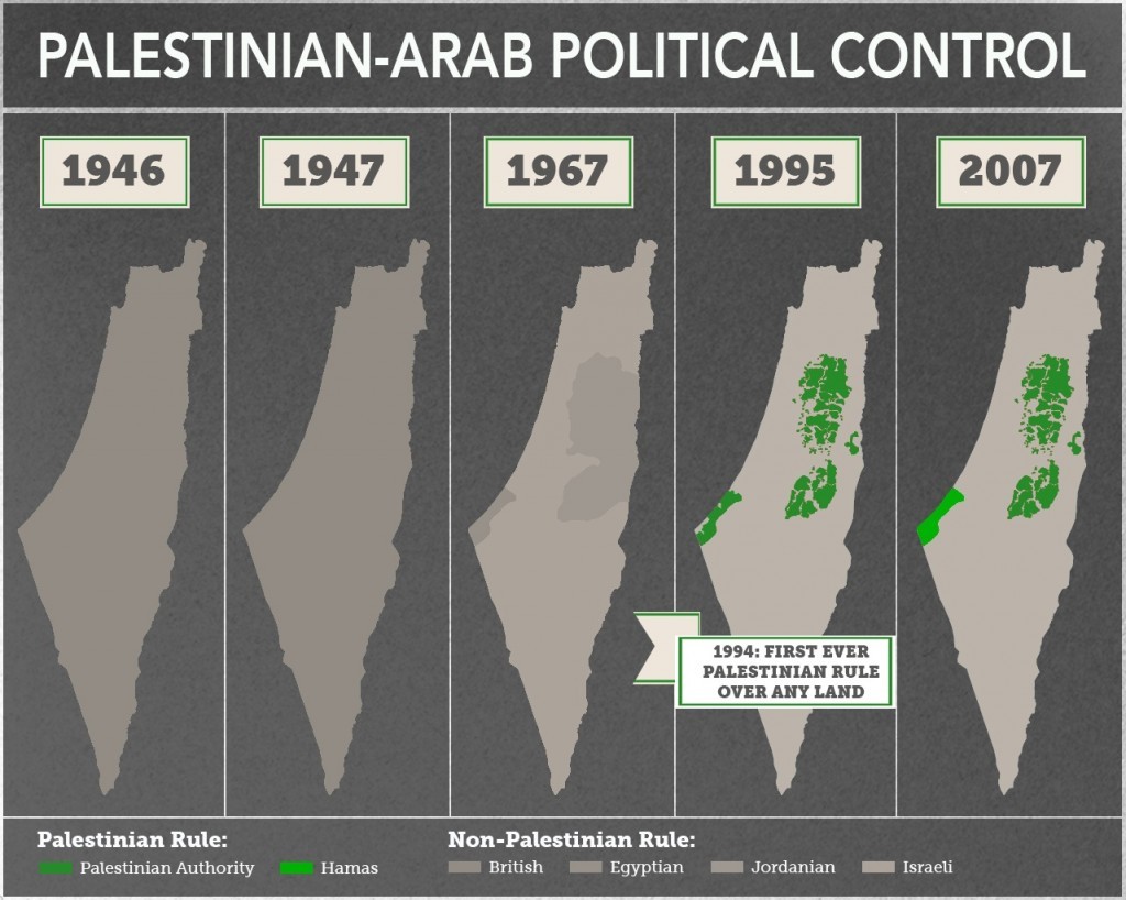
Mor wrote that the series of maps broadcast by MSNBC conflate different aspects of land control. One shows inhabited areas, another shows a proposed partition plan, and two more show political control. Mor argued that if one looked at a series of maps showing the history of Palestinian political control, a true picture emerges.
The categories of political control and international partition plans are quite easy to map out over time. Since the concern of those publicizing the maps above is Palestinian control of land, we can illustrate this with a more honest series of maps showing areas of political control, using the same years as the original—adding one for clarity.
As seen above, 1946 has exactly zero land under Palestinian Arab control—not autonomous, not sovereign, not anything—as it was all under British authority. We could go further back in time, to the Ottoman era, for example, and the map wouldn’t change in the slightest. 1947 sees no changes to the map, as Palestine was still under British control. Before the war in June 1967, control is divided between three states, and none of them is Palestinian. The 2005 map would be exactly as it is presented in the original series, showing the very first lands ever be ruled by Palestinian Arabs qua Palestinian Arabs. To clarify this a bit more, I have added a map from 1995, showing the withdrawals undertaken during the first two years of the Oslo process, just up to but not including the 1997 Hebron Protocol.In fact, if we zoomed in a bit more, we would see how the peace process of the 1990s resulted in the first time a Palestinian Arab regime ruled over any piece of land. This occurred in 1994 with the establishment of the Palestinian Authority in Gaza and Jericho. That control steadily expanded over more and more land during the years leading up to the failed final status talks. Much of it was then lost during the second intifada, but eventually regained as violence died down, and the Gaza disengagement even expanded it slightly. All of these Palestinian land gains have taken place in the last 20 years and every square meter of it came not from Turkey or Britain or Jordan or Egypt, but from Israel alone; and nearly all of it through peace negotiations.
[Photo: Moi May / YouTube ]


